
Flypix
AI enabled geospatial solutions
| About | Details |
|---|---|
| Name: | Flypix |
| Submited By: | Malachi Armstrong |
| Release Date | 1 year ago |
| Website | Visit Website |
| Category | Maps Tech |
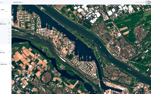
Create AI use cases with Aerial and Satellite Imagery: detect objects and segment land on earth observation data. NO knowledge about AI or Machine Learning is required.
A colleague of mine was recently looking for a way to streamline their geospatial data analysis. FlyPix looks like the perfect fit.
2 years ago
User-friendly interface and powerful AI capabilities of FlyPix are truly remarkable. It’s great to see such a well-rounded tool.
2 years ago
I love how easy it is to use this tool to detect specific objects in images. The ability to identify anything from trash to solar panels with a few examples is a game-changer for analysis
2 years ago
I never thought I'd get excited about geospatial tech, but FlyPix is making it look so cool and useful!
2 years ago
Related Apps
-
 MarketingIdeas.com
Never run out of marketing ideas ever again
-
 GoIT LMS
Empowering emerging markets with high-quality tech education
-
 Cloaked
Virtual identities to protect your privacy
-
 Rask AI
Say it in any language, AI based, sounds as good as a human
-
 Attio
AttioCustomizable, collaborative CRM for startups
-
 Solidus Ai Tech
Powering the Future of Artificial Intelligence
-
 deco.cx 2.0
Build web apps 10x faster with Deno, JSX, TS & Tailwind
-
 Pitch 2.0
Create, share and analyze presentations faster than ever
-
 Kodezi 2.0
Grammarly for programmers
-
 Novu
NovuThe open-source notification infrastructure for developers